IMAGES TAKEN NEAR TO
Waldron Drive, MAIDSTONE, ME15 9TH
Introduction
This page details the photographs taken nearby to Waldron Drive, ME15 9TH by members of the Geograph project.
The Geograph project started in 2005 with the aim of publishing, organising and preserving representative images for every square kilometre of Great Britain, Ireland and the Isle of Man.

There are currently over 7.5m images from over14,400 individuals and you can help contribute to the project by visiting https://www.geograph.org.uk
Image Map
Images are licensed for reuse under creativecommons.org/licenses/by-sa/2.0
Notes
- Clicking on the map will re-center to the selected point.
- The higher the marker number, the further away the image location is from the centre of the postcode.
Image Listing (37 Images Found)
Images are licensed for reuse under creativecommons.org/licenses/by-sa/2.0
Image
Details
Distance
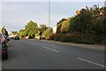
2
Loose Road, Loose
The cotoneaster berries are in full bloom.
Image: © David Howard
Taken: 28 Aug 2022
0.09 miles
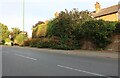
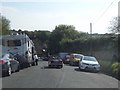
3
Loose Road
See similar view from 1966 Image
Image: © Oast House Archive
Taken: 3 Sep 2010
0.11 miles
4
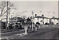
Maidstone Corporation trolleybus at Loose
Taken in 1965 at the terminus at the top of Old Loose Hill. The Maidstone trolleybus system closed in April 1967 but motorbuses had started to appear on its two routes two years before. The vehicle seen here is one of five Sunbeam Ws built in 1943-44 but re-bodied by Roe in 1960. In this view it is about to leave for Barming (Bull Inn) on the other side of town. Although the houses in Loose Road are still there the 'Kings Arms' public house (whose sign can be seen here) is not.
Image: © David Kemp
Taken: 1 Jan 1965
0.11 miles
5
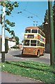
British Trolleybuses - Maidstone
Maidstone was the smallest British trolleybus system to survive into the 60s. It was basically a single route from Barming in the west to Sutton Road in the south with a branch off the latter to Loose. This resulted in the splendid destination display to be seen in this picture.
This trolleybus is arriving at the Loose terminus which was a few hundred yards short of the old village itself, at the top of Old Loose Hill. The surroundings appear to be little changed, although the pub sign pole (at the left) no longer appears to be there.
For a slide show of British Trolleybuses in the late 60s http://www.geograph.org.uk/search.php?i=1773236&displayclass=slide
Image: © Alan Murray-Rust
Taken: 10 Sep 1966
0.12 miles
6
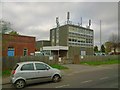
Loose Telephone Exchange, Loose Road
With a lot of aerials on the roof, presumably to do with mobile telephony and broadband.
Image: © Danny P Robinson
Taken: 5 Apr 2014
0.12 miles
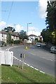
9
Old Loose Hill, Loose
Loose is a village just on the southern fringe of the Maidstone built up area.
Image: © David Howard
Taken: 8 May 2016
0.13 miles
10
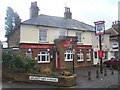
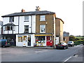
The Walnut Tree Public House, Loose
On junction of Walnut Tree Avenue and Loose Road (on right).
Image: © David Anstiss
Taken: 5 Mar 2009
0.13 miles