IMAGES TAKEN NEAR TO
Grant Drive, MAIDSTONE, ME15 9RZ
Introduction
This page details the photographs taken nearby to Grant Drive, ME15 9RZ by members of the Geograph project.
The Geograph project started in 2005 with the aim of publishing, organising and preserving representative images for every square kilometre of Great Britain, Ireland and the Isle of Man.

There are currently over 7.5m images from over14,400 individuals and you can help contribute to the project by visiting https://www.geograph.org.uk
Image Map
Images are licensed for reuse under creativecommons.org/licenses/by-sa/2.0
Notes
- Clicking on the map will re-center to the selected point.
- The higher the marker number, the further away the image location is from the centre of the postcode.
Image Listing (18 Images Found)
Images are licensed for reuse under creativecommons.org/licenses/by-sa/2.0
Image
Details
Distance
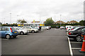
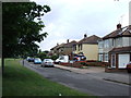
6
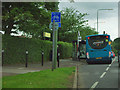
Bus stop by Morrisons
Arriva fleet number 4013 on route 82 pauses. Morrisons supermarket is through a gap in the hedge.
Image: © Robin Webster
Taken: 9 Jul 2012
0.20 miles
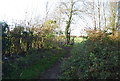
8
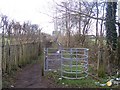
Kissing Gate on footpath
Path from Pested Bar Road, leading to Boughton Lane.
Image: © David Anstiss
Taken: 20 Jan 2009
0.21 miles
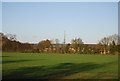
10
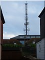
Communication Mast in Police HQ
Mast in Kent County Constabulary Headquarters. As seen from Grove Road.
Image: © David Anstiss
Taken: 20 Jan 2009
0.21 miles