IMAGES TAKEN NEAR TO
Paynes Lane, MAIDSTONE, ME15 9QZ
Introduction
This page details the photographs taken nearby to Paynes Lane, ME15 9QZ by members of the Geograph project.
The Geograph project started in 2005 with the aim of publishing, organising and preserving representative images for every square kilometre of Great Britain, Ireland and the Isle of Man.

There are currently over 7.5m images from over14,400 individuals and you can help contribute to the project by visiting https://www.geograph.org.uk
Image Map
Images are licensed for reuse under creativecommons.org/licenses/by-sa/2.0
Notes
- Clicking on the map will re-center to the selected point.
- The higher the marker number, the further away the image location is from the centre of the postcode.
Image Listing (57 Images Found)
Images are licensed for reuse under creativecommons.org/licenses/by-sa/2.0
Image
Details
Distance
4

Boughton Lane
Looking south by the entrance to Oldborough Manor Community and Five Acre Woods schools, Boughton Lane runs from the Loose Road to Boughton Monchelsea.
Image: © Richard Sanders
Taken: 29 Nov 2005
0.12 miles
10
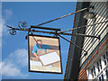
Papermakers Arms sign
Sign for Image], a closed pub on the A229 Loose Road.
Image: © Oast House Archive
Taken: 24 Jul 2011
0.15 miles