IMAGES TAKEN NEAR TO
St. Nicholas Way, ME15 8ZD
Introduction
This page details the photographs taken nearby to St. Nicholas Way, ME15 8ZD by members of the Geograph project.
The Geograph project started in 2005 with the aim of publishing, organising and preserving representative images for every square kilometre of Great Britain, Ireland and the Isle of Man.

There are currently over 7.5m images from over14,400 individuals and you can help contribute to the project by visiting https://www.geograph.org.uk
Image Map
Images are licensed for reuse under creativecommons.org/licenses/by-sa/2.0
Notes
- Clicking on the map will re-center to the selected point.
- The higher the marker number, the further away the image location is from the centre of the postcode.
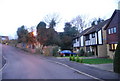
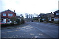
Image Listing (54 Images Found)
Images are licensed for reuse under creativecommons.org/licenses/by-sa/2.0
Image
Details
Distance
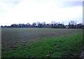
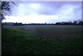
5

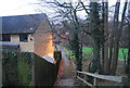
Footpath to Willington
Footpath from Church Road along the side of a field into Willington.
Image: © Oast House Archive
Taken: 22 Mar 2012
0.10 miles

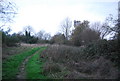
10
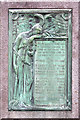
St Nicholas, Otham, Kent - War Memorial
War Memorial 1914 to 1918
Image: © John Salmon
Taken: 27 May 2003
0.13 miles