IMAGES TAKEN NEAR TO
Mallard Way, MAIDSTONE, ME15 8XH
Introduction
This page details the photographs taken nearby to Mallard Way, ME15 8XH by members of the Geograph project.
The Geograph project started in 2005 with the aim of publishing, organising and preserving representative images for every square kilometre of Great Britain, Ireland and the Isle of Man.

There are currently over 7.5m images from over14,400 individuals and you can help contribute to the project by visiting https://www.geograph.org.uk
Image Map
Images are licensed for reuse under creativecommons.org/licenses/by-sa/2.0
Notes
- Clicking on the map will re-center to the selected point.
- The higher the marker number, the further away the image location is from the centre of the postcode.
Image Listing (39 Images Found)
Images are licensed for reuse under creativecommons.org/licenses/by-sa/2.0
Image
Details
Distance
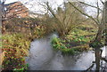
1
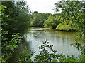
Lake by Mallards Way
Next to, or part of, the recreation ground here, and close to the River Len.
Image: © Robin Webster
Taken: 17 Jul 2012
0.04 miles
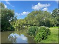
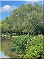
4
Mallard Lake on the River Len
Used by Len Valley Preservation and Angling Society. Restricted Members Only club, with no day tickets to allow plenty of fish in lake. Footpath on left used by the Len Valley Walk (long distance path) from Mallard Way to Otham Lane.
Image: © David Anstiss
Taken: 26 Dec 2008
0.05 miles
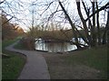
5
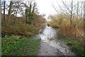
Flooding on the Len Valley Walk, Spot Lane
Image: © N Chadwick
Taken: 29 Nov 2009
0.05 miles
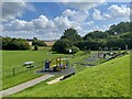
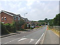
10
Signpost, Spot Lane
Cycleway 17 & the Len Valley Walk part company at this point
Image: © N Chadwick
Taken: 29 Nov 2009
0.07 miles