IMAGES TAKEN NEAR TO
Cotswold Gardens, MAIDSTONE, ME15 8TB
Introduction
This page details the photographs taken nearby to Cotswold Gardens, ME15 8TB by members of the Geograph project.
The Geograph project started in 2005 with the aim of publishing, organising and preserving representative images for every square kilometre of Great Britain, Ireland and the Isle of Man.

There are currently over 7.5m images from over14,400 individuals and you can help contribute to the project by visiting https://www.geograph.org.uk
Image Map
Images are licensed for reuse under creativecommons.org/licenses/by-sa/2.0
Notes
- Clicking on the map will re-center to the selected point.
- The higher the marker number, the further away the image location is from the centre of the postcode.
Image Listing (48 Images Found)
Images are licensed for reuse under creativecommons.org/licenses/by-sa/2.0
Image
Details
Distance
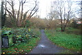
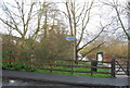
3
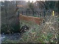
Footbridge over River Len
Leads from Gault Close to Spot Lane
Image: © David Anstiss
Taken: 26 Dec 2008
0.02 miles
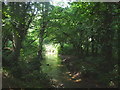
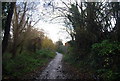
4
Spot Lane, Downswood
This road has been used as a path since the building of the Downswood estate in the 1980s.
Image: © Chris Whippet
Taken: 14 Jul 2013
0.03 miles

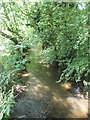
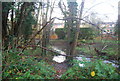
8
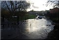
Flooding on Spot Lane
The River Len overflowed its banks causing this localised flooding
Image: © N Chadwick
Taken: 29 Nov 2009
0.05 miles
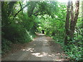
10
Signpost, Spot Lane
Cycleway 17 & the Len Valley Walk part company at this point
Image: © N Chadwick
Taken: 29 Nov 2009
0.07 miles