IMAGES TAKEN NEAR TO
Avery Lane, MAIDSTONE, ME15 8RZ
Introduction
This page details the photographs taken nearby to Avery Lane, ME15 8RZ by members of the Geograph project.
The Geograph project started in 2005 with the aim of publishing, organising and preserving representative images for every square kilometre of Great Britain, Ireland and the Isle of Man.

There are currently over 7.5m images from over14,400 individuals and you can help contribute to the project by visiting https://www.geograph.org.uk
Image Map
Images are licensed for reuse under creativecommons.org/licenses/by-sa/2.0
Notes
- Clicking on the map will re-center to the selected point.
- The higher the marker number, the further away the image location is from the centre of the postcode.
Image Listing (11 Images Found)
Images are licensed for reuse under creativecommons.org/licenses/by-sa/2.0
Image
Details
Distance
1

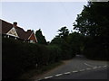
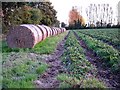
Vapour trails in the sunset
The ghostly "mummies" in the foreground are rolls of fabric for protecting the Image
Image: © Penny Mayes
Taken: 20 Oct 2005
0.07 miles
2
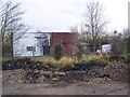
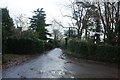
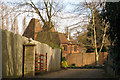
Rear of Vandalised Telephone Exchange
On Back Lane, a private drive to Holly Farm and other houses. But is also a public footpath.
Image: © David Anstiss
Taken: 20 Jan 2009
0.07 miles
4
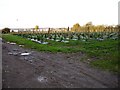
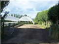
Raspberry canes and polytunnels
North of Avery Lane at Otham Hole.
Image: © Penny Mayes
Taken: 20 Oct 2005
0.14 miles
5
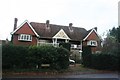
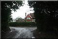
Holly Farm Oast, Holly Farm Road, Otham, Kent
Image: © Oast House Archive
Taken: 7 Feb 2008
0.18 miles