IMAGES TAKEN NEAR TO
Mote Park, MAIDSTONE, ME15 8QU
Introduction
This page details the photographs taken nearby to Mote Park, ME15 8QU by members of the Geograph project.
The Geograph project started in 2005 with the aim of publishing, organising and preserving representative images for every square kilometre of Great Britain, Ireland and the Isle of Man.

There are currently over 7.5m images from over14,400 individuals and you can help contribute to the project by visiting https://www.geograph.org.uk
Image Map
Images are licensed for reuse under creativecommons.org/licenses/by-sa/2.0
Notes
- Clicking on the map will re-center to the selected point.
- The higher the marker number, the further away the image location is from the centre of the postcode.
Image Listing (67 Images Found)
Images are licensed for reuse under creativecommons.org/licenses/by-sa/2.0
Image
Details
Distance
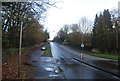
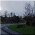
2
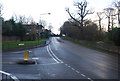
Wellington St, Deringwood Drive junction
Image: © N Chadwick
Taken: 29 Nov 2009
0.01 miles
4
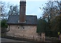
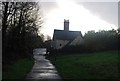
Entrance to Mote Park and Otham Lodge
On Willington Street, opposite Derring Wood Drive.
Mote Park is large park within Maidstone allowing plenty of space for dog walking, children playing, feeding ducks and other park activities. Also on Len Valley Walk through park.
Image: © David Anstiss
Taken: 26 Dec 2008
0.02 miles
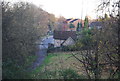
6
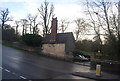
Otham Lodge & Wellington St entrance to Mote Park
Image: © N Chadwick
Taken: 29 Nov 2009
0.03 miles
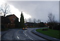
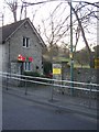
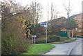
9
Sign for Downswood estate, Deringwood Drive
Image: © N Chadwick
Taken: 29 Nov 2009
0.05 miles
10
Signpost for Len Valley Walk & Cycleway 17 off Deringwood Drive
Image: © N Chadwick
Taken: 29 Nov 2009
0.06 miles