IMAGES TAKEN NEAR TO
Willington Street, MAIDSTONE, ME15 8ED
Introduction
This page details the photographs taken nearby to Willington Street, ME15 8ED by members of the Geograph project.
The Geograph project started in 2005 with the aim of publishing, organising and preserving representative images for every square kilometre of Great Britain, Ireland and the Isle of Man.

There are currently over 7.5m images from over14,400 individuals and you can help contribute to the project by visiting https://www.geograph.org.uk
Image Map
Images are licensed for reuse under creativecommons.org/licenses/by-sa/2.0
Notes
- Clicking on the map will re-center to the selected point.
- The higher the marker number, the further away the image location is from the centre of the postcode.
Image Listing (74 Images Found)
Images are licensed for reuse under creativecommons.org/licenses/by-sa/2.0
Image
Details
Distance
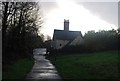
4
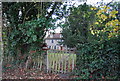
Mote Cottage
Grade II listed. http://www.britishlistedbuildings.co.uk/en-173450-mote-cottage-maidstone
Image: © N Chadwick
Taken: 27 Nov 2011
0.10 miles

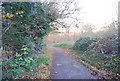
7
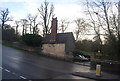
Otham Lodge & Wellington St entrance to Mote Park
Image: © N Chadwick
Taken: 29 Nov 2009
0.11 miles
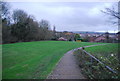
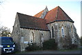
8
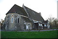
Cobtree Hall
The old parish church of St John, now a community centre.
Image: © N Chadwick
Taken: 27 Nov 2011
0.11 miles
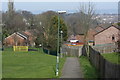
9
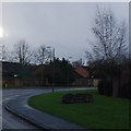
Sign for Downswood estate, Deringwood Drive
Image: © N Chadwick
Taken: 29 Nov 2009
0.11 miles
10
Cobtree Hall
The old parish church of St John, now a community centre.
Image: © N Chadwick
Taken: 27 Nov 2011
0.11 miles