IMAGES TAKEN NEAR TO
Melville Road, MAIDSTONE, ME15 7UY
Introduction
This page details the photographs taken nearby to Melville Road, ME15 7UY by members of the Geograph project.
The Geograph project started in 2005 with the aim of publishing, organising and preserving representative images for every square kilometre of Great Britain, Ireland and the Isle of Man.

There are currently over 7.5m images from over14,400 individuals and you can help contribute to the project by visiting https://www.geograph.org.uk
Image Map
Images are licensed for reuse under creativecommons.org/licenses/by-sa/2.0
Notes
- Clicking on the map will re-center to the selected point.
- The higher the marker number, the further away the image location is from the centre of the postcode.
Image Listing (258 Images Found)
Images are licensed for reuse under creativecommons.org/licenses/by-sa/2.0
Image
Details
Distance
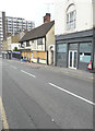
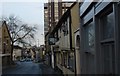
1
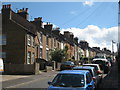
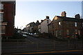
Melville Road
Terraced houses to both sides. Looking from junction with Mote Road.
Image: © Oast House Archive
Taken: 3 Sep 2010
0.01 miles
2
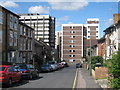
Melville Road
Offices tower blocks to rear.
Image: © Oast House Archive
Taken: 3 Sep 2010
0.02 miles
3
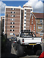
Melville Road
Typical transport needed to get around Maidstone.
Image: © Oast House Archive
Taken: 3 Sep 2010
0.02 miles
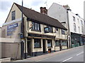
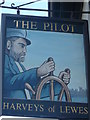
5
The Pilot, 25, Upper Stone Street
This image shows Image when it was open; it closed in March 2017.
Image: © John Baker
Taken: 17 Jun 2018
0.03 miles
6
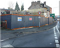
20-28, Mote Road
Planning permission has been granted by Maidstone Borough Council under application number 18/504734/FULL for the “redevelopment of Maidstone Mosque with associated facilities including a residential flat, two retail units and ancillary accommodation (resubmission of 18/502567/FULL)”.
Image: © John Baker
Taken: 21 Jan 2020
0.03 miles
8
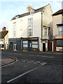
29 & 31, Upper Stone Street
Both properties are grade II listed and date from the late 18th century to early 19th century. Their exteriors are cement rendered and they are built of three storeys, with two dormers set in a slate mansard roof. On the second floor, there are three windows, two have sashes and the other is blank. The first floor, there are three windows, two are round-headed with triple sashes and the third is blank. There are bow window on the first floor of each side elevation. The shop fronts were added later http://www.britishlistedbuildings.co.uk/en-421906-29-and-31-upper-stone-street-kent#.WF1uUP5vjcc
Number 29 houses Polski Salon, which specializes in hair and beauty while number 31 appears to be disused.
Image: © John Baker
Taken: 27 Nov 2016
0.04 miles
9
The Pilot, A229
Grade II listed. http://www.britishlistedbuildings.co.uk/en-421905-27-maidstone
Image: © N Chadwick
Taken: 28 Nov 2010
0.04 miles
10
The Pilot, Public House, Maidstone
Outside Image
Image: © David Anstiss
Taken: 18 Nov 2012
0.04 miles