IMAGES TAKEN NEAR TO
Kingsley Road, MAIDSTONE, ME15 7UW
Introduction
This page details the photographs taken nearby to Kingsley Road, ME15 7UW by members of the Geograph project.
The Geograph project started in 2005 with the aim of publishing, organising and preserving representative images for every square kilometre of Great Britain, Ireland and the Isle of Man.

There are currently over 7.5m images from over14,400 individuals and you can help contribute to the project by visiting https://www.geograph.org.uk
Image Map
Images are licensed for reuse under creativecommons.org/licenses/by-sa/2.0
Notes
- Clicking on the map will re-center to the selected point.
- The higher the marker number, the further away the image location is from the centre of the postcode.
Image Listing (169 Images Found)
Images are licensed for reuse under creativecommons.org/licenses/by-sa/2.0
Image
Details
Distance
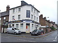
1
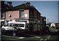
The Kingsley Arms Public House, Maidstone
On junction of Brunswick Street East (on left) and 36 Melville Road (on right).
Image: © David Anstiss
Taken: 5 Apr 2009
0.06 miles
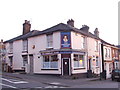
9
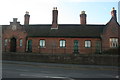
Hunter's Almshouses
Grade II listed. http://www.britishlistedbuildings.co.uk/en-173452-hunter-s-almshouses-kent
Image: © N Chadwick
Taken: 25 Nov 2012
0.10 miles
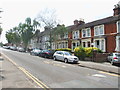
10
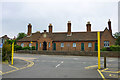
Almshouses, Mote Road, Maidstone
Dated 1851, an extension to Hunter's Almshouses, which are off to the right but in a different, plainer style. A grade II listed building.
Image: © Robin Webster
Taken: 27 Jun 2012
0.10 miles