IMAGES TAKEN NEAR TO
Square Hill Road, MAIDSTONE, ME15 7TN
Introduction
This page details the photographs taken nearby to Square Hill Road, ME15 7TN by members of the Geograph project.
The Geograph project started in 2005 with the aim of publishing, organising and preserving representative images for every square kilometre of Great Britain, Ireland and the Isle of Man.

There are currently over 7.5m images from over14,400 individuals and you can help contribute to the project by visiting https://www.geograph.org.uk
Image Map
Images are licensed for reuse under creativecommons.org/licenses/by-sa/2.0
Notes
- Clicking on the map will re-center to the selected point.
- The higher the marker number, the further away the image location is from the centre of the postcode.
Image Listing (127 Images Found)
Images are licensed for reuse under creativecommons.org/licenses/by-sa/2.0
Image
Details
Distance

4
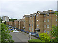
Flats, Riverbank Close, Maidstone
The river being the River Len, behind the buildings.
Image: © Robin Webster
Taken: 27 Jun 2012
0.07 miles

7
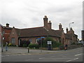
Hunters Almshouses Extension
Grade II listed building, Nos 64 - 70, on the junction of Hastings Road (on the left) and Mote Road (on the right).
See http://www.britishlistedbuildings.co.uk/en-173453-64-70-maidstone for more details about the building.
Image: © David Anstiss
Taken: 13 Jul 2011
0.09 miles