IMAGES TAKEN NEAR TO
St. Philips Avenue, MAIDSTONE, ME15 7SW
Introduction
This page details the photographs taken nearby to St. Philips Avenue, ME15 7SW by members of the Geograph project.
The Geograph project started in 2005 with the aim of publishing, organising and preserving representative images for every square kilometre of Great Britain, Ireland and the Isle of Man.

There are currently over 7.5m images from over14,400 individuals and you can help contribute to the project by visiting https://www.geograph.org.uk
Image Map
Images are licensed for reuse under creativecommons.org/licenses/by-sa/2.0
Notes
- Clicking on the map will re-center to the selected point.
- The higher the marker number, the further away the image location is from the centre of the postcode.
Image Listing (69 Images Found)
Images are licensed for reuse under creativecommons.org/licenses/by-sa/2.0
Image
Details
Distance
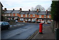
9
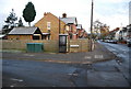
Telephone box, Waterloo St, Hastings Rd junction
Image: © N Chadwick
Taken: 28 Nov 2010
0.08 miles
10
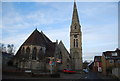
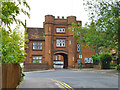
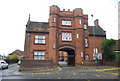
St Philip's Church
St. Philip's Church was built in the 1860's and its tower and spire were added in 1878. The tower is a brick structure faced in local ragstone.
Image: © N Chadwick
Taken: 28 Nov 2010
0.08 miles