IMAGES TAKEN NEAR TO
Highland Road, MAIDSTONE, ME15 7QF
Introduction
This page details the photographs taken nearby to Highland Road, ME15 7QF by members of the Geograph project.
The Geograph project started in 2005 with the aim of publishing, organising and preserving representative images for every square kilometre of Great Britain, Ireland and the Isle of Man.

There are currently over 7.5m images from over14,400 individuals and you can help contribute to the project by visiting https://www.geograph.org.uk
Image Map (Loading...)


Getting Data...Please wait
Leaflet Map data © OpenStreetMap
Images are licensed for reuse under creativecommons.org/licenses/by-sa/2.0
Notes
- Clicking on the map will re-center to the selected point.
- The higher the marker number, the further away the image location is from the centre of the postcode.
Image Listing (18 Images Found)
Images are licensed for reuse under creativecommons.org/licenses/by-sa/2.0
Image
Details
Distance
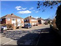
4
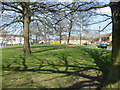
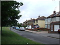
A green on Shepway
Shepway is a large estate to the south-east of Maidstone. It is higher than the centre of Maidstone and there are views to the North Downs. Many of the roads are named after current or former counties. To the left of this green is Westmorland Road, while to the right is Buckingham Row. Beyond Westmorland Road is Westmorland Green - see http://www.geograph.org.uk/photo/3913235
Image: © Marathon
Taken: 1 Apr 2014
0.13 miles
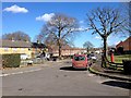
5
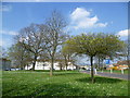
Westmorland Green, Shepway
Shepway is a large estate to the south-east of Maidstone. It is higher than the centre of Maidstone and there are views to the North Downs. Many of the roads are named after current or former counties. This green is surrounded by the road called Westmorland Green while Westmorland Road is to the right.
Image: © Marathon
Taken: 1 Apr 2014
0.13 miles
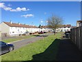
6
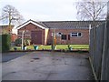
Kingdom Hall of Jehovah's Witnesses
Accessed from car park behind Cheshire Road Houses.
Image: © David Anstiss
Taken: 20 Jan 2009
0.13 miles
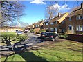
9
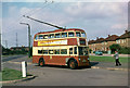
British Trolleybuses - Maidstone
Trolleybus 86 waits at Nottingham Avenue on Sutton Road. This was a short working on the Park Wood route, and was only used by a small number of journeys at peak periods. The conductor has taken the opportunity to purchase an evening paper.
The vehicle was bought second hand from the Hastings system when it closed in 1959 and would have done nearly 20 years service when the Maidstone trolleybuses finished.
The road junction here has been remodelled since the picture was taken; the traffic island has been merged with the green beyond the vehicle and it be impossible to make the same manoeuvre today.
For a slide show of British Trolleybuses in the late 60s
http://www.geograph.org.uk/search.php?i=1773236&displayclass=slide
Image: © Alan Murray-Rust
Taken: 10 Sep 1966
0.18 miles