IMAGES TAKEN NEAR TO
Sussex Road, MAIDSTONE, ME15 7HX
Introduction
This page details the photographs taken nearby to Sussex Road, ME15 7HX by members of the Geograph project.
The Geograph project started in 2005 with the aim of publishing, organising and preserving representative images for every square kilometre of Great Britain, Ireland and the Isle of Man.

There are currently over 7.5m images from over14,400 individuals and you can help contribute to the project by visiting https://www.geograph.org.uk
Image Map
Images are licensed for reuse under creativecommons.org/licenses/by-sa/2.0
Notes
- Clicking on the map will re-center to the selected point.
- The higher the marker number, the further away the image location is from the centre of the postcode.
Image Listing (35 Images Found)
Images are licensed for reuse under creativecommons.org/licenses/by-sa/2.0
Image
Details
Distance
7
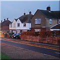
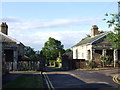
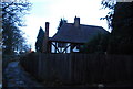
Former Lodge Keepers Cottages for Mote Park
Former Estate buildings now private homes. Gate in middle is footpath entrance to Park from Claygate Road.
Image: © David Anstiss
Taken: 20 Jan 2009
0.15 miles
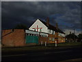
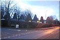
9
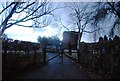
Half timbered cottage on the edge of Mote Park
Image: © N Chadwick
Taken: 29 Nov 2009
0.16 miles
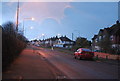
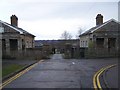
10
Sure Start Children's Centre, Rutland Way
Image: © N Chadwick
Taken: 29 Nov 2009
0.16 miles