IMAGES TAKEN NEAR TO
Square Hill, MAIDSTONE, ME15 7FA
Introduction
This page details the photographs taken nearby to Square Hill, ME15 7FA by members of the Geograph project.
The Geograph project started in 2005 with the aim of publishing, organising and preserving representative images for every square kilometre of Great Britain, Ireland and the Isle of Man.

There are currently over 7.5m images from over14,400 individuals and you can help contribute to the project by visiting https://www.geograph.org.uk
Image Map
Images are licensed for reuse under creativecommons.org/licenses/by-sa/2.0
Notes
- Clicking on the map will re-center to the selected point.
- The higher the marker number, the further away the image location is from the centre of the postcode.
Image Listing (116 Images Found)
Images are licensed for reuse under creativecommons.org/licenses/by-sa/2.0
Image
Details
Distance
1
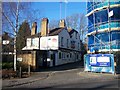
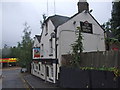
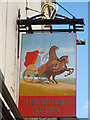
The British Queen Pub, Maidstone
On junction of Square Hill Road and River Bank.
Houses being built on the right of the photo are by Combe Bank Homes, five apartments with a deluxe penthouse with roof garden.
Image: © David Anstiss
Taken: 26 Dec 2008
0.00 miles
2
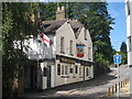
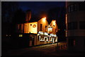
The British Queen, Maidstone
A Shepherd Neame pub on Square Hill.
Image: © Oast House Archive
Taken: 3 Sep 2010
0.00 miles
4
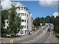
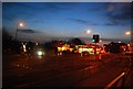
New apartments on Square Hill Road
Constructed in 2008, replacing a house.
Image: © Oast House Archive
Taken: 3 Sep 2010
0.01 miles