IMAGES TAKEN NEAR TO
Heather Drive, MAIDSTONE, ME15 7DG
Introduction
This page details the photographs taken nearby to Heather Drive, ME15 7DG by members of the Geograph project.
The Geograph project started in 2005 with the aim of publishing, organising and preserving representative images for every square kilometre of Great Britain, Ireland and the Isle of Man.

There are currently over 7.5m images from over14,400 individuals and you can help contribute to the project by visiting https://www.geograph.org.uk
Image Map
Images are licensed for reuse under creativecommons.org/licenses/by-sa/2.0
Notes
- Clicking on the map will re-center to the selected point.
- The higher the marker number, the further away the image location is from the centre of the postcode.
Image Listing (42 Images Found)
Images are licensed for reuse under creativecommons.org/licenses/by-sa/2.0
Image
Details
Distance
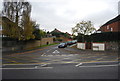
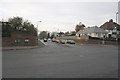
5
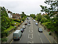
Loose Road is not flowing freely
The A229 leaving town shortly sheds to the left the A274, and traffic is queueing up to the lights. Several of the roads around central Maidstone feature junctions which significantly hold up traffic. This is 1:50 p.m., not even rush hour. Other towns of similar or larger size seem to do a good deal better with their traffic.
Image: © Robin Webster
Taken: 27 Jun 2012
0.09 miles
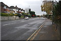
7
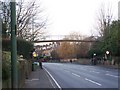
Footbridge over A229 Loose Road
Used mainly by schoolchildren, avoiding crossing the very busy road. Maidstone Grammar School is on right-hand side of road, and a primary school is on the left hand side of the road.
Image: © David Anstiss
Taken: 20 Jan 2009
0.12 miles
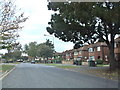
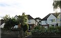
9
Armstrong Road
The junction of Loose Road and Armstrong Road looking west along Armstrong Road towards South Park and the Hockey Club. The road is also home to the former Maidstone Borough Council bus depot now part of the Arriva Group.
Image: © Richard Sanders
Taken: 30 Nov 2005
0.13 miles
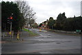
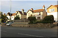
10
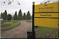
South Park
The aptly named South Park is situated to the south of Maidstone and is bisected by Armstrong Road. This is the northerly part of the park, featuring a bowling green, tennis courts, pitch and putt course and a fish pond. This view is looking north from the entrance.
Image: © Richard Sanders
Taken: 30 Nov 2005
0.13 miles