IMAGES TAKEN NEAR TO
Barton Road, MAIDSTONE, ME15 7BX
Introduction
This page details the photographs taken nearby to Barton Road, ME15 7BX by members of the Geograph project.
The Geograph project started in 2005 with the aim of publishing, organising and preserving representative images for every square kilometre of Great Britain, Ireland and the Isle of Man.

There are currently over 7.5m images from over14,400 individuals and you can help contribute to the project by visiting https://www.geograph.org.uk
Image Map
Images are licensed for reuse under creativecommons.org/licenses/by-sa/2.0
Notes
- Clicking on the map will re-center to the selected point.
- The higher the marker number, the further away the image location is from the centre of the postcode.
Image Listing (62 Images Found)
Images are licensed for reuse under creativecommons.org/licenses/by-sa/2.0
Image
Details
Distance
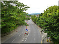
7
Turn right for Tovil
Straight on for Hastings
Image: © David Howard
Taken: 19 Jun 2016
0.09 miles
8
Loose Road, Maidstone
Heading towards the town centre.
Image: © Robin Webster
Taken: 27 Jun 2012
0.09 miles
9
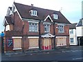
The Eagle Pub, Maidstone
Closed pub on junction of A29 (2) Loose Road and Old Tovil Road (on right).
Image: © David Anstiss
Taken: 20 Jan 2009
0.10 miles