IMAGES TAKEN NEAR TO
South Park Road, MAIDSTONE, ME15 7AH
Introduction
This page details the photographs taken nearby to South Park Road, ME15 7AH by members of the Geograph project.
The Geograph project started in 2005 with the aim of publishing, organising and preserving representative images for every square kilometre of Great Britain, Ireland and the Isle of Man.

There are currently over 7.5m images from over14,400 individuals and you can help contribute to the project by visiting https://www.geograph.org.uk
Image Map
Images are licensed for reuse under creativecommons.org/licenses/by-sa/2.0
Notes
- Clicking on the map will re-center to the selected point.
- The higher the marker number, the further away the image location is from the centre of the postcode.
Image Listing (8 Images Found)
Images are licensed for reuse under creativecommons.org/licenses/by-sa/2.0
Image
Details
Distance
3
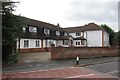
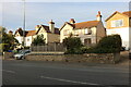
The Oast care home, 2 Plains Avenue, Maidstone
"The Oast Care Home" is presumably named after a large five round kiln oast house which was once adjacent the site.
Image: © Oast House Archive
Taken: 15 Aug 2014
0.18 miles
4
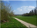
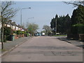
Mote Park
Mote Park is the major park in Maidstone. The house was built in 1793-1801 for Lord Romney by D. A. Alexander, who was later to be the architect of Maidstone and Dartmoor Prisons. It was his only major country house and Pevsner described it as 'forbidding'. The lake was formed by damming the River Len and the house is to the north-east of the lake.
This southern part of the park often feels a little quieter than the part closest to the centre of Maidstone. This is the path from the York Road entrance. In the distance can be seen the Volunteers Pavilion. For a close up of this and more information see http://www.geograph.org.uk/photo/3915459 The North Downs are in the far distance.
Image: © Marathon
Taken: 1 Apr 2014
0.19 miles
5
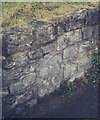
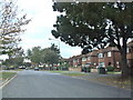
Old Milestone by the A229, Loose Road, Maidstone
Cranbrook stone by the A229, in parish of Maidstone (Maidstone District), Loose Road, near junction with Plains Avenue, in stone embankment wall - residual shape only as it is very weathered.
Inscription once read:-
(Maidstone)
(1)
(Cranbrook)
(13)
Milestone Society National ID: KE_MDCB01
Image: © Milestone Society
Taken: Unknown
0.20 miles
7
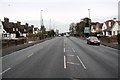
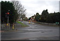
Loose Road
Looking north towards Maidstone and the junction with Armstrong Road, this is the A229 Hastings road.
Image: © Richard Sanders
Taken: 30 Nov 2005
0.24 miles