IMAGES TAKEN NEAR TO
Runcie Close, MAIDSTONE, ME15 6ZJ
Introduction
This page details the photographs taken nearby to Runcie Close, ME15 6ZJ by members of the Geograph project.
The Geograph project started in 2005 with the aim of publishing, organising and preserving representative images for every square kilometre of Great Britain, Ireland and the Isle of Man.

There are currently over 7.5m images from over14,400 individuals and you can help contribute to the project by visiting https://www.geograph.org.uk
Image Map (Loading...)


Getting Data...Please wait
Leaflet Map data © OpenStreetMap
Images are licensed for reuse under creativecommons.org/licenses/by-sa/2.0
Notes
- Clicking on the map will re-center to the selected point.
- The higher the marker number, the further away the image location is from the centre of the postcode.
Image Listing (22 Images Found)
Images are licensed for reuse under creativecommons.org/licenses/by-sa/2.0
Image
Details
Distance
4
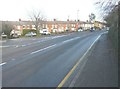
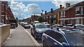
Terrace of houses along Tovil Road
Church Road branches off to the left.
Image: © John Baker
Taken: 2 Jan 2014
0.17 miles
5
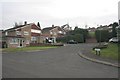
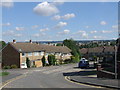
Avington Close
The parish of Tovil has seen an explosion of house building since the early 1970s. This Wimpey estate, built near the edge of the Parish boundary in the mid-70s, is on the site of a former quarry that was partially refilled, hence the difference in levels between Avington Close and Rainham Close in the background. An ancient footpath that runs left to right behind the fir trees in the centre of the picture was retained when the estate was built. Going to the right, the footpath leads to Straw Mill Hill and the former milling region of the Loose Valley Image
Image: © Richard Sanders
Taken: 30 Nov 2005
0.18 miles
6
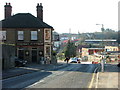
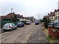
Tovil Hill
The changing face of Tovil. This is looking ESE. The pub's name, The Royal Paper Mill, reflects that this was once an area of paper mills. The mill that stood to the left of the bottom of the hill has long gone and is now a housing estate. It was adjacent to Straw Mill Hill that leads into the Loose Valley where several other mills stood. More houses are under construction up Farleigh Hill in the background.
Image: © Richard Sanders
Taken: 14 Jan 2005
0.18 miles
8
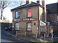
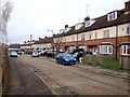
The Royal Paper Mill Pub, Tovil
On 39 Tovil Hill Road, opposite Church Street.
Image: © David Anstiss
Taken: 21 Jan 2009
0.19 miles