IMAGES TAKEN NEAR TO
Forest Hill, MAIDSTONE, ME15 6UU
Introduction
This page details the photographs taken nearby to Forest Hill, ME15 6UU by members of the Geograph project.
The Geograph project started in 2005 with the aim of publishing, organising and preserving representative images for every square kilometre of Great Britain, Ireland and the Isle of Man.

There are currently over 7.5m images from over14,400 individuals and you can help contribute to the project by visiting https://www.geograph.org.uk
Image Map
Images are licensed for reuse under creativecommons.org/licenses/by-sa/2.0
Notes
- Clicking on the map will re-center to the selected point.
- The higher the marker number, the further away the image location is from the centre of the postcode.
Image Listing (36 Images Found)
Images are licensed for reuse under creativecommons.org/licenses/by-sa/2.0
Image
Details
Distance
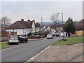
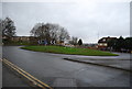
2
Postley Road, Maidstone (2)
Near the junction of Courtenay Road and Armstrong Road.
Image: © Danny P Robinson
Taken: 8 Mar 2011
0.04 miles
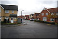
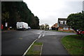
7
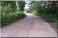
Postley Road, Maidstone (3)
This track will be upgraded to a roadway if Taylor Wimpey get to build new housing on the Hayle Place Stud Farm site immediately to the left of this picture.
Image: © Danny P Robinson
Taken: 21 May 2012
0.10 miles
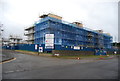
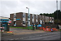
8
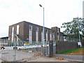
Empty depot, Armstrong Road, Maidstone
Image: © Chris Whippet
Taken: 12 Oct 2010
0.10 miles