IMAGES TAKEN NEAR TO
Romney Place, MAIDSTONE, ME15 6SF
Introduction
This page details the photographs taken nearby to Romney Place, ME15 6SF by members of the Geograph project.
The Geograph project started in 2005 with the aim of publishing, organising and preserving representative images for every square kilometre of Great Britain, Ireland and the Isle of Man.

There are currently over 7.5m images from over14,400 individuals and you can help contribute to the project by visiting https://www.geograph.org.uk
Image Map
Images are licensed for reuse under creativecommons.org/licenses/by-sa/2.0
Notes
- Clicking on the map will re-center to the selected point.
- The higher the marker number, the further away the image location is from the centre of the postcode.
Image Listing (354 Images Found)
Images are licensed for reuse under creativecommons.org/licenses/by-sa/2.0
Image
Details
Distance
2
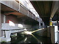
River Len, Maidstone
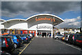
This is not a very attractive part of the river here. It is the gap between the Chequers Centre (left) and the Sainsbury's Superstore (right).
Image: © Danny P Robinson
Taken: 1 Feb 2015
0.03 miles
3
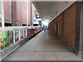
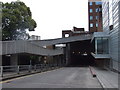
Walkway from Sainsbury's to the Bus Station and the High Street
Image: © Danny P Robinson
Taken: 1 Feb 2015
0.03 miles
4
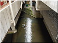
Between Maidstone Bus Station and Sainsbury's
The bus station is part of the Chequers Shopping Centre. On the right is a walkway leading between the bus station and the supermarket.
Below is a forgotten section of the River Len, running between Maidstone and Lenham. With obligatory shopping market trolleys in the water!
Image: © David Anstiss
Taken: 19 Jun 2011
0.03 miles
5
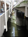
River Len under Sainsbury's
The River Len heads from Moat Park, towards the River Medway. It passes through the town centre, mostly covered up and in culverts.
This small section is beside the delievery area to the store (below the shoppers carpark).
Above on the left, is the bus station within the Chequers Centre shopping centre.
Image: © David Anstiss
Taken: 18 Nov 2012
0.04 miles
6
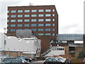
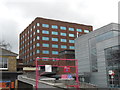
Maidstone House, King Street, ME15 6JQ (2)
These are the offices for Maidstone Borough Council. Sainsbury's superstore is in the foreground.
Image: © Danny P Robinson
Taken: 29 Mar 2015
0.04 miles
7
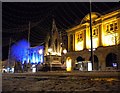
Maidstone Queen's Monument
This photo was taken after the heavy snow in January 2010. You can see the Queen's Monument and the Nat West behind on the High Street
Image: © rob
Taken: 5 Jan 2010
0.05 miles
9
Maidstone House, King Street, ME15 6JQ (1)
These are the offices of Maidstone Borough Council. In the foreground is the Maidstone Gateway and an access to a town centre car park.
Image: © Danny P Robinson
Taken: 29 Mar 2015
0.06 miles
10
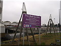
The Mall Garden (under construction), Maidstone
This small plot of land is at the junction of Pad's Hill (leading into Maidstone Bus Station beside the Chequers Shopping Centre - on the left) and Padsole Lane.
In the background is the ramp access to Sainsbury's.
The two plant supports are in the shape of Oast Houses!
Image: © David Anstiss
Taken: 22 Mar 2013
0.06 miles