IMAGES TAKEN NEAR TO
Campbell Road, MAIDSTONE, ME15 6PY
Introduction
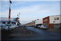
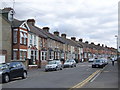
This page details the photographs taken nearby to Campbell Road, ME15 6PY by members of the Geograph project.
The Geograph project started in 2005 with the aim of publishing, organising and preserving representative images for every square kilometre of Great Britain, Ireland and the Isle of Man.

There are currently over 7.5m images from over14,400 individuals and you can help contribute to the project by visiting https://www.geograph.org.uk
Image Map
Images are licensed for reuse under creativecommons.org/licenses/by-sa/2.0
Notes
- Clicking on the map will re-center to the selected point.
- The higher the marker number, the further away the image location is from the centre of the postcode.
Image Listing (193 Images Found)
Images are licensed for reuse under creativecommons.org/licenses/by-sa/2.0
Image
Details
Distance
4
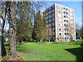
College Court, Maidstone
The block of flats called College Court are seen from Hayle Road (A229) which is part of the one way system to the south of central Maidstone.
Image: © Marathon
Taken: 1 Apr 2014
0.06 miles
6
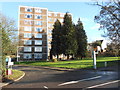
College Court, Hayle Rd, Maidstone, Kent ME15 6PB
Image: © Danny P Robinson
Taken: 28 Jan 2015
0.07 miles