IMAGES TAKEN NEAR TO
The Spillway, MAIDSTONE, ME15 6FE
Introduction
This page details the photographs taken nearby to The Spillway, ME15 6FE by members of the Geograph project.
The Geograph project started in 2005 with the aim of publishing, organising and preserving representative images for every square kilometre of Great Britain, Ireland and the Isle of Man.

There are currently over 7.5m images from over14,400 individuals and you can help contribute to the project by visiting https://www.geograph.org.uk
Image Map
Images are licensed for reuse under creativecommons.org/licenses/by-sa/2.0
Notes
- Clicking on the map will re-center to the selected point.
- The higher the marker number, the further away the image location is from the centre of the postcode.
Image Listing (77 Images Found)
Images are licensed for reuse under creativecommons.org/licenses/by-sa/2.0
Image
Details
Distance
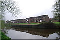
5
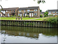
Houses by the River Medway
A development largely on the site of a paper mill.
Image: © Robin Webster
Taken: 27 Jun 2012
0.11 miles
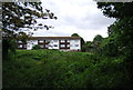
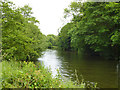
7

Miller's Wharf, River Medway
A new riverside development.
Image: © N Chadwick
Taken: 13 Apr 2009
0.11 miles
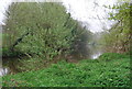
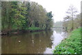
10
Medway Valley line above the Medway Valley Walk
Image: © N Chadwick
Taken: 13 Apr 2009
0.12 miles