IMAGES TAKEN NEAR TO
Rockwell Court, MAIDSTONE, ME15 6EQ
Introduction
This page details the photographs taken nearby to Rockwell Court, ME15 6EQ by members of the Geograph project.
The Geograph project started in 2005 with the aim of publishing, organising and preserving representative images for every square kilometre of Great Britain, Ireland and the Isle of Man.

There are currently over 7.5m images from over14,400 individuals and you can help contribute to the project by visiting https://www.geograph.org.uk
Image Map
Images are licensed for reuse under creativecommons.org/licenses/by-sa/2.0
Notes
- Clicking on the map will re-center to the selected point.
- The higher the marker number, the further away the image location is from the centre of the postcode.
Image Listing (13 Images Found)
Images are licensed for reuse under creativecommons.org/licenses/by-sa/2.0
Image
Details
Distance
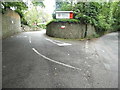
1
Houses on Farleigh Hill
Looking downhill. The terraced houses are stepped with the slope of the hill.
Image: © Oast House Archive
Taken: 29 Sep 2009
0.03 miles
3
Stockett Lane, Tovil
Kent Fire Service is on the left
Image: © David Howard
Taken: 19 Jun 2016
0.14 miles
4
The entrance to Kent Fire Service, Tovil
Image: © David Howard
Taken: 19 Jun 2016
0.14 miles
5
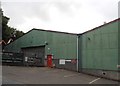
Warehouses on Burial Ground Lane, Tovil
Image: © David Howard
Taken: 19 Jun 2016
0.16 miles
6
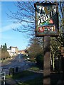
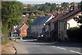
Tovil Village Sign
On Tovil Hill, leading in to Maidstone. Woodbridge Drive is in background on right; it leads into a housing estate.
Image: © David Anstiss
Taken: 21 Jan 2009
0.18 miles
7
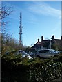
The Godlands and Communications Mast
On separate access road off Stockett Lane. The Green family owned Hayle Mill Image In 1895, Herbert Green, built a large house on top of the western bank in the Loose Valley, overlooking his mill. This is now the Kent Fire And Rescue Service Headquarters.
Image: © David Anstiss
Taken: 21 Jan 2009
0.22 miles
8
Railway Goods Station entrance remnants
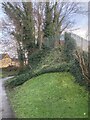
The rail fencing indicates where the bridge carried the Railway into the goods yard for the Tovil Branch.
https://tinyurl.com/y46yqckv
Image: © Trevor Edward Streeter
Taken: 16 Jan 2021
0.23 miles
9
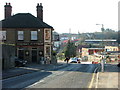
Tovil Hill
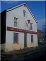
The changing face of Tovil. This is looking ESE. The pub's name, The Royal Paper Mill, reflects that this was once an area of paper mills. The mill that stood to the left of the bottom of the hill has long gone and is now a housing estate. It was adjacent to Straw Mill Hill that leads into the Loose Valley where several other mills stood. More houses are under construction up Farleigh Hill in the background.
Image: © Richard Sanders
Taken: 14 Jan 2005
0.24 miles