IMAGES TAKEN NEAR TO
Melrose Close, MAIDSTONE, ME15 6BD
Introduction
This page details the photographs taken nearby to Melrose Close, ME15 6BD by members of the Geograph project.
The Geograph project started in 2005 with the aim of publishing, organising and preserving representative images for every square kilometre of Great Britain, Ireland and the Isle of Man.

There are currently over 7.5m images from over14,400 individuals and you can help contribute to the project by visiting https://www.geograph.org.uk
Image Map
Images are licensed for reuse under creativecommons.org/licenses/by-sa/2.0
Notes
- Clicking on the map will re-center to the selected point.
- The higher the marker number, the further away the image location is from the centre of the postcode.
Image Listing (42 Images Found)
Images are licensed for reuse under creativecommons.org/licenses/by-sa/2.0
Image
Details
Distance
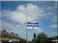
2
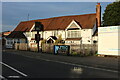
Houses on Loose Road, Maidstone
The Swan pub is on the left with Chummy's seafood stall.
Image: © David Howard
Taken: 28 Aug 2022
0.08 miles
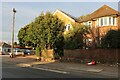
6
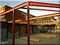
Extension to Loose Road Shops
Physiofit (shown in Image] ) has been demolished and they are operating from temporary premises whilst this new facility is being constructed for them.
Image: © Danny P Robinson
Taken: 6 May 2014
0.09 miles
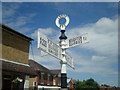
7
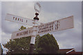
Old Direction Sign - Signpost by the A229, Loose Road
Annulus finial - 4 arms; Kent CC parish halo by the A229, in parish of Loose (Maidstone District), Loose Road, junction with Cripple Street and Broughton Lane, on pavement.
Surveyed
Milestone Society National ID: KE_TQ7653
Image: © Milestone Society
Taken: Unknown
0.10 miles
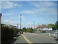
9
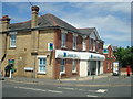
Lloyds TSB Bank, Loose Road
The bank was attacked by ram-raiders a few months after this photo was taken. The cash machine was removed by thieves using a digger, and the bank suffered considerable structural damage as a result. News story here: http://www.bbc.co.uk/news/uk-england-kent-11749778
Image: © Stacey Harris
Taken: 18 Jul 2010
0.10 miles
10
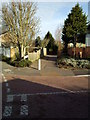
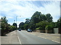
Footpath at Junction of Warnford Gardens and Runnymede Gardens, Maidstone
A shortcut between the shops at the junction of Cripple Street / Loose Road, and Broadoak Avenue.
Image: © Danny P Robinson
Taken: 11 Mar 2011
0.10 miles