IMAGES TAKEN NEAR TO
Bishops Lane, MAIDSTONE, ME15 0SJ
Introduction
This page details the photographs taken nearby to Bishops Lane, ME15 0SJ by members of the Geograph project.
The Geograph project started in 2005 with the aim of publishing, organising and preserving representative images for every square kilometre of Great Britain, Ireland and the Isle of Man.

There are currently over 7.5m images from over14,400 individuals and you can help contribute to the project by visiting https://www.geograph.org.uk
Image Map
Images are licensed for reuse under creativecommons.org/licenses/by-sa/2.0
Notes
- Clicking on the map will re-center to the selected point.
- The higher the marker number, the further away the image location is from the centre of the postcode.
Image Listing (19 Images Found)
Images are licensed for reuse under creativecommons.org/licenses/by-sa/2.0
Image
Details
Distance
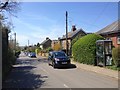
2
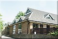
Cottages , Hunton
The unusual gothic windows are receiving attention. There is another similar pair of cottages here, the other side of a central row of cottages which are particularly ornate.
Image: © Robin Webster
Taken: 24 Feb 2007
0.04 miles
8
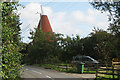
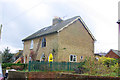
Gudgeon Oast, West Street, Hunton, Kent
Image: © Oast House Archive
Taken: 3 Sep 2006
0.18 miles
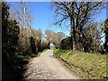
9
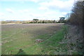
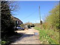
Footpath KM162 off West Street
Running along the field edge.
Image: © Julian P Guffogg
Taken: 2 Feb 2013
0.18 miles