IMAGES TAKEN NEAR TO
West Street, MAIDSTONE, ME15 0RR
Introduction
This page details the photographs taken nearby to West Street, ME15 0RR by members of the Geograph project.
The Geograph project started in 2005 with the aim of publishing, organising and preserving representative images for every square kilometre of Great Britain, Ireland and the Isle of Man.

There are currently over 7.5m images from over14,400 individuals and you can help contribute to the project by visiting https://www.geograph.org.uk
Image Map
Images are licensed for reuse under creativecommons.org/licenses/by-sa/2.0
Notes
- Clicking on the map will re-center to the selected point.
- The higher the marker number, the further away the image location is from the centre of the postcode.
Image Listing (36 Images Found)
Images are licensed for reuse under creativecommons.org/licenses/by-sa/2.0
Image
Details
Distance
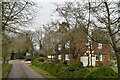
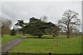
2
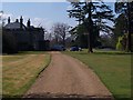
Hunton Court
On access road of West Street. Note, Palladian bridge on right over lake in garden.
This large house was once owned by Sir Henry Campbell-Bannerman, a former British Prime Minister. He was inheritted the estate from his uncle Henry Bannerman. See http://en.wikipedia.org/wiki/Henry_Campbell-Bannerman for more details about the man.
Image: © David Anstiss
Taken: 1 Apr 2009
0.05 miles
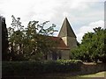
3
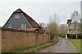
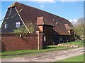
Barn, Hunton Court Farm
Grade II listed.
Image: © N Chadwick
Taken: 18 Mar 2021
0.05 miles
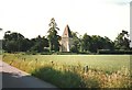
10
Church Barn
On access road for Hunton Court Farm.
Image: © David Anstiss
Taken: 1 Apr 2009
0.08 miles