IMAGES TAKEN NEAR TO
Wilsons Lane, MAIDSTONE, ME15 0LU
Introduction
This page details the photographs taken nearby to Wilsons Lane, ME15 0LU by members of the Geograph project.
The Geograph project started in 2005 with the aim of publishing, organising and preserving representative images for every square kilometre of Great Britain, Ireland and the Isle of Man.

There are currently over 7.5m images from over14,400 individuals and you can help contribute to the project by visiting https://www.geograph.org.uk
Image Map
Images are licensed for reuse under creativecommons.org/licenses/by-sa/2.0
Notes
- Clicking on the map will re-center to the selected point.
- The higher the marker number, the further away the image location is from the centre of the postcode.
Image Listing (41 Images Found)
Images are licensed for reuse under creativecommons.org/licenses/by-sa/2.0
Image
Details
Distance
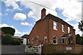
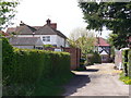
1
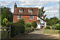
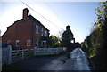
Highlands Farmhouse
Grade II listed. https://historicengland.org.uk/listing/the-list/list-entry/1249687
Image: © N Chadwick
Taken: 22 Aug 2020
0.02 miles

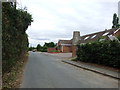
7
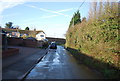
Pleasant Valley Road
Minor residential road off Dean Street, East Farleigh which is now having its "toothgap sites" filled up by new houses.
Image: © Colin Smith
Taken: 26 Apr 2008
0.05 miles