IMAGES TAKEN NEAR TO
Gallants Lane, MAIDSTONE, ME15 0LE
Introduction
This page details the photographs taken nearby to Gallants Lane, ME15 0LE by members of the Geograph project.
The Geograph project started in 2005 with the aim of publishing, organising and preserving representative images for every square kilometre of Great Britain, Ireland and the Isle of Man.

There are currently over 7.5m images from over14,400 individuals and you can help contribute to the project by visiting https://www.geograph.org.uk
Image Map
Images are licensed for reuse under creativecommons.org/licenses/by-sa/2.0
Notes
- Clicking on the map will re-center to the selected point.
- The higher the marker number, the further away the image location is from the centre of the postcode.
Image Listing (25 Images Found)
Images are licensed for reuse under creativecommons.org/licenses/by-sa/2.0
Image
Details
Distance
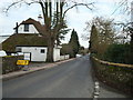

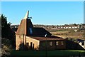
6

Court Lodge Farm Oast, Lower Road, East Farleigh, Kent
Image: © Oast House Archive
Taken: 19 Jun 2008
0.15 miles
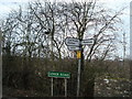
7
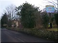
Village Sign on B2010 Lower Road
On road coming into village from West Farleigh.
Image: © David Anstiss
Taken: 26 Jan 2009
0.15 miles
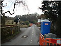
9
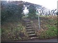
Steps up to footpath
On Gallants Lane. Path leads to B2010, Lower Road, near East Farleigh Church.
Image: © David Anstiss
Taken: 26 Jan 2009
0.18 miles