IMAGES TAKEN NEAR TO
Lower Road, MAIDSTONE, ME15 0JL
Introduction
This page details the photographs taken nearby to Lower Road, ME15 0JL by members of the Geograph project.
The Geograph project started in 2005 with the aim of publishing, organising and preserving representative images for every square kilometre of Great Britain, Ireland and the Isle of Man.

There are currently over 7.5m images from over14,400 individuals and you can help contribute to the project by visiting https://www.geograph.org.uk
Image Map
Images are licensed for reuse under creativecommons.org/licenses/by-sa/2.0
Notes
- Clicking on the map will re-center to the selected point.
- The higher the marker number, the further away the image location is from the centre of the postcode.
Image Listing (219 Images Found)
Images are licensed for reuse under creativecommons.org/licenses/by-sa/2.0
Image
Details
Distance
1
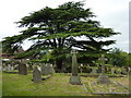
The churchyard of St. Mary's , East Farleigh
Image: © pam fray
Taken: 31 May 2010
0.03 miles
2
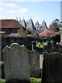
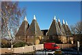
Court Lodge Oast
Seen through graves at St. Mary's Church.
Image: © Oast House Archive
Taken: 23 Mar 2011
0.04 miles
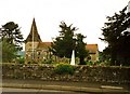
4

St Mary's, East Farleigh
Parish church with Saxon roots. It contains Culpeper family memorials.
Image: © Colin Smith
Taken: 26 Apr 2008
0.04 miles

6
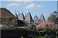
Court Lodge Farm Oast, Lower Road, East Farleigh, Kent
Image: © Oast House Archive
Taken: 23 Mar 2011
0.04 miles

10

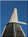
East Farleigh : kilns and cowls, Court Lodge Farm Oast
Find out more at Image]
Image: © Jim Osley
Taken: 28 Aug 2024
0.04 miles