IMAGES TAKEN NEAR TO
Busbridge Road, MAIDSTONE, ME15 0HZ
Introduction
This page details the photographs taken nearby to Busbridge Road, ME15 0HZ by members of the Geograph project.
The Geograph project started in 2005 with the aim of publishing, organising and preserving representative images for every square kilometre of Great Britain, Ireland and the Isle of Man.

There are currently over 7.5m images from over14,400 individuals and you can help contribute to the project by visiting https://www.geograph.org.uk
Image Map
Images are licensed for reuse under creativecommons.org/licenses/by-sa/2.0
Notes
- Clicking on the map will re-center to the selected point.
- The higher the marker number, the further away the image location is from the centre of the postcode.
Image Listing (29 Images Found)
Images are licensed for reuse under creativecommons.org/licenses/by-sa/2.0
Image
Details
Distance
3
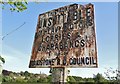
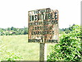
Pre-Worboys sign on Busbridge Road, Loose Hill
The design looks pre-1930s standardisation, issued by the local council who would have been responsible for all road signs at the time. There is a second one at the other end which has been repainted, while this has apparently been forgotten.
Image: © David Howard
Taken: 8 May 2016
0.11 miles
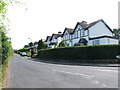
5
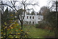
Woodlawn
Grade II listed. http://www.britishlistedbuildings.co.uk/en-432915-woodlawn-loose
Image: © N Chadwick
Taken: 27 Nov 2011
0.12 miles
8

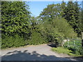
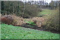
Footpath junction near Loose Court Farm
Path from Kirkdale Road, climbs down valley past the farm, and over footbridge (farm track bridge) in the scrub (near the valley stream) and then it heads up the valley to Busbridge Road, near Pympe's Court. Crossing this, is the Loose Valley path, which goes over the stile to Kirkdale Street, from Bockingford Lane.
Image: © David Anstiss
Taken: 21 Jan 2009
0.16 miles
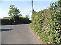
10
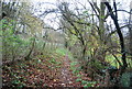
Riverside path in the Loose Valley
The Loose stream rises near Langley and flows into the river Medway near Tovil. For several hundred years until the early 20th century the valley was a local centre of industry with a number of ragstone quarries and a series of 13 water-powered mills. The historian William Lambarde recorded that the mills all existed in 1570. At various times they were engaged in fulling woollen cloth, paper making and corn grinding. They have all either been demolished or long ceased working but the Loose Valley and the sites of the mills were designated a Conservation Area by Maidstone Borough Council in 2000.
This path is alongside the Loose stream and a number of ponds on the way to Loose Village. Willows line the stream here.
Image: © Marathon
Taken: 18 Jan 2014
0.17 miles