IMAGES TAKEN NEAR TO
Lower Road, MAIDSTONE, ME15 0HD
Introduction
This page details the photographs taken nearby to Lower Road, ME15 0HD by members of the Geograph project.
The Geograph project started in 2005 with the aim of publishing, organising and preserving representative images for every square kilometre of Great Britain, Ireland and the Isle of Man.

There are currently over 7.5m images from over14,400 individuals and you can help contribute to the project by visiting https://www.geograph.org.uk
Image Map
Images are licensed for reuse under creativecommons.org/licenses/by-sa/2.0
Notes
- Clicking on the map will re-center to the selected point.
- The higher the marker number, the further away the image location is from the centre of the postcode.
Image Listing (224 Images Found)
Images are licensed for reuse under creativecommons.org/licenses/by-sa/2.0
Image
Details
Distance
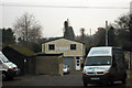
1
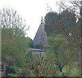
The top of an oast house in East Farleigh
Image: © N Chadwick
Taken: 13 Apr 2009
0.01 miles
3
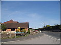
Kilnbridge Close at the junction of Lower Road
Image: © David Howard
Taken: 8 May 2016
0.06 miles
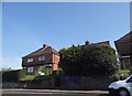
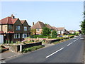
5
Little Court Lodge Farm, Lower Road, East Farleigh
Image: © Oast House Archive
Taken: 29 Jan 2009
0.09 miles
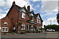
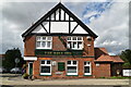
7
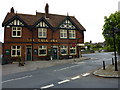
The Bull Inn, East Farleigh
On the corner of Station Hill and Lower Road.
Image: © pam fray
Taken: 31 May 2010
0.09 miles
9
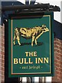
The Bull Inn sign
Compare with older sign Image
Image: © Oast House Archive
Taken: 3 Feb 2019
0.10 miles