IMAGES TAKEN NEAR TO
Well Street, MAIDSTONE, ME15 0EW
Introduction
This page details the photographs taken nearby to Well Street, ME15 0EW by members of the Geograph project.
The Geograph project started in 2005 with the aim of publishing, organising and preserving representative images for every square kilometre of Great Britain, Ireland and the Isle of Man.

There are currently over 7.5m images from over14,400 individuals and you can help contribute to the project by visiting https://www.geograph.org.uk
Image Map
Images are licensed for reuse under creativecommons.org/licenses/by-sa/2.0
Notes
- Clicking on the map will re-center to the selected point.
- The higher the marker number, the further away the image location is from the centre of the postcode.
Image Listing (6 Images Found)
Images are licensed for reuse under creativecommons.org/licenses/by-sa/2.0
Image
Details
Distance
1
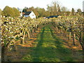
Blossoming Orchard, Loose
In the background are houses on Linton Road. The trees are either apple or pear. They have been pruned to keep branches low and short.
Image: © Danny P Robinson
Taken: 6 Apr 2011
0.15 miles
2
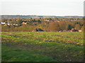
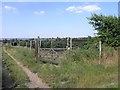
Former Orchard, Loose
The pattern of planting and the tracks between is still evident. The North Downs are in the background.
Image: © Danny P Robinson
Taken: 6 Apr 2011
0.19 miles
3
Orchards
One of the many orchards that surround Loose
Image: © Hywel Williams
Taken: 2 Jul 2006
0.21 miles