IMAGES TAKEN NEAR TO
Kirkdale, MAIDSTONE, ME15 0EA
Introduction
This page details the photographs taken nearby to Kirkdale, ME15 0EA by members of the Geograph project.
The Geograph project started in 2005 with the aim of publishing, organising and preserving representative images for every square kilometre of Great Britain, Ireland and the Isle of Man.

There are currently over 7.5m images from over14,400 individuals and you can help contribute to the project by visiting https://www.geograph.org.uk
Image Map
Images are licensed for reuse under creativecommons.org/licenses/by-sa/2.0
Notes
- Clicking on the map will re-center to the selected point.
- The higher the marker number, the further away the image location is from the centre of the postcode.
Image Listing (144 Images Found)
Images are licensed for reuse under creativecommons.org/licenses/by-sa/2.0
Image
Details
Distance
2
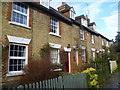
Kirkdale Cottages, Loose
Kirkdale Cottages are next to a footpath leading north from the village of Loose. In the centre of the cottages is a plaque on the wall which says 'KIRKDALE COTTAGES, 1868'.
Image: © Marathon
Taken: 18 Jan 2014
0.00 miles
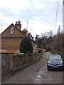
4
Cottage by Loose Stream
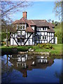
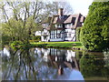
Half-timbered cottage facing the Brooks Path. The stream once powered a water mill.
Image: © Colin Smith
Taken: 26 Apr 2008
0.02 miles
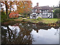
5
Streamside Loose
Reflections of half-timbered cottage in Loose Stream. The stream formerly powered a water mill.
Image: © Colin Smith
Taken: 26 Apr 2008
0.02 miles
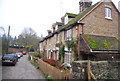
6
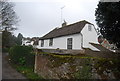
The Dairy House
Grade II listed. http://www.britishlistedbuildings.co.uk/en-432885-the-dairy-house-loose
Image: © N Chadwick
Taken: 27 Nov 2011
0.02 miles
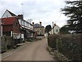
7

Kirkdale Path towards Kirkdale Cottages, Loose
This path, since incorporated into the KCC network, crossed the Loose Court Estate/Farm
Image: © Peter Rigby
Taken: 28 Mar 2015
0.03 miles
8
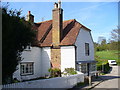
Florence House
White weatherboarded cottage, formerly a shop, in the valley bottom at Loose village.
Image: © Colin Smith
Taken: 26 Apr 2008
0.03 miles
9
Tyler's at Loose in autumn
The Loose stream rises near Langley and flows into the River Medway near Tovil. For several hundred years until the early 20th century the valley was a local centre of industry with a number of ragstone quarries and a series of 13 water-powered mills. The historian William Lambarde recorded that the mills all existed in 1570. At various times they were engaged in fulling woollen cloth, paper making and corn grinding. They have all either been demolished or long ceased working but the Loose Valley and the sites of the mills were designated a Conservation Area by Maidstone Borough Council in 2000.
The name Loose seems to come from the Old English 'hlose' meaning 'place of pigs', probably reflecting the main activity of the local Saxon peasants.
This view is from the causeway between Old Loose Hill and Kirkdale which separates the Loose stream from the millpond, both of which served Loose Mill in Bridge Street until it closed in 1912. This looks across the millpond to the timber-framed Tyler's, once three cottages but much altered since.
Image: © Marathon
Taken: 9 Nov 2019
0.04 miles