IMAGES TAKEN NEAR TO
Malthouse Hill, MAIDSTONE, ME15 0BP
Introduction
This page details the photographs taken nearby to Malthouse Hill, ME15 0BP by members of the Geograph project.
The Geograph project started in 2005 with the aim of publishing, organising and preserving representative images for every square kilometre of Great Britain, Ireland and the Isle of Man.

There are currently over 7.5m images from over14,400 individuals and you can help contribute to the project by visiting https://www.geograph.org.uk
Image Map
Images are licensed for reuse under creativecommons.org/licenses/by-sa/2.0
Notes
- Clicking on the map will re-center to the selected point.
- The higher the marker number, the further away the image location is from the centre of the postcode.
Image Listing (144 Images Found)
Images are licensed for reuse under creativecommons.org/licenses/by-sa/2.0
Image
Details
Distance
1

Rose Cottages, Old Loose Hill
Built 1877 according to the inscription. The close called Malthouse Hill ascends on the right.
Image: © Robin Webster
Taken: 9 Jul 2012
0.03 miles
2
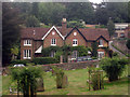
Rose Cottages, Old Loose Hill, Loose
Built in 1877.
Image: © Oast House Archive
Taken: 20 Sep 2009
0.03 miles
3
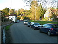
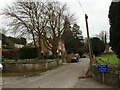
Old Loose Hill
At the junction with Church Street. The water channel contains a small stream -- there are many springs nearby.
Image: © Danny P Robinson
Taken: 6 Apr 2011
0.04 miles
5
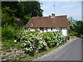
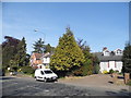
Approaching Loose from the south
Coming from the south and turning off the A229 into Old Loose Hill, this attractive cottage is reached where High Banks rises steeply to the left. High Banks here is level with the roof of the cottage to the left.
Image: © Marathon
Taken: 24 Jun 2014
0.05 miles
9
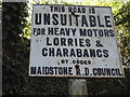
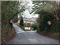
Pre-Worboys sign on High Banks, Loose
Usually a sign naming a council can't really qualify as pre-Worboys as not part of a national series, but as far as I know there were no national signs issued before the Transport Act in 1933. This has been maintained like new unlike the slightly hidden one (also in my stream) at the other end of the road which is covered in surface rust.
Image: © David Howard
Taken: 8 May 2016
0.06 miles
10
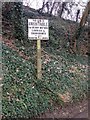
Pre-Worboys Maidstone Rural District sign, High Banks, Loose
Image: © Chris Whippet
Taken: 26 Feb 2016
0.06 miles