IMAGES TAKEN NEAR TO
Old Loose Hill, MAIDSTONE, ME15 0BH
Introduction
This page details the photographs taken nearby to Old Loose Hill, ME15 0BH by members of the Geograph project.
The Geograph project started in 2005 with the aim of publishing, organising and preserving representative images for every square kilometre of Great Britain, Ireland and the Isle of Man.

There are currently over 7.5m images from over14,400 individuals and you can help contribute to the project by visiting https://www.geograph.org.uk
Image Map
Images are licensed for reuse under creativecommons.org/licenses/by-sa/2.0
Notes
- Clicking on the map will re-center to the selected point.
- The higher the marker number, the further away the image location is from the centre of the postcode.
Image Listing (140 Images Found)
Images are licensed for reuse under creativecommons.org/licenses/by-sa/2.0
Image
Details
Distance
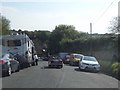
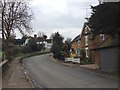
1
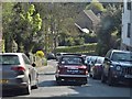
Triumph Herald on Old Loose Hill
This was like new, it must have been fully restored
Image: © David Howard
Taken: 8 May 2016
0.04 miles
2
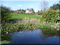
The Loose stream at Loose
The Loose stream rises near Langley and flows into the River Medway near Tovil. For several hundred years until the early 20th century the valley was a local centre of industry with a number of ragstone quarries and a series of 13 water-powered mills. The historian William Lambarde recorded that the mills all existed in 1570. At various times they were engaged in fulling woollen cloth, paper making and corn grinding. They have all either been demolished or long ceased working but the Loose Valley and the sites of the mills were designated a Conservation Area by Maidstone Borough Council in 2000.
The name Loose seems to come from the Old English 'hlose' meaning 'place of pigs', probably reflecting the main activity of the local Saxon peasants.
This view is from the causeway between Old Loose Hill and Kirkdale which separates the Loose stream from the millpond, both of which served Loose Mill in Bridge Street until it closed in 1912. This looks across the millpond to a house on Old Loose Hill.
Image: © Marathon
Taken: 1 Apr 2014
0.04 miles
3
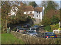
Old Loose Hill
From beside the Chequers pub and stream.
Image: © Oast House Archive
Taken: 19 Nov 2010
0.05 miles
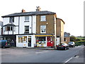
4
Loose Post Office
The post office is at the top of Old Loose Hill leading down to Loose village in the valley below.
Image: © Robert Taylor
Taken: 6 May 2007
0.05 miles
5
Old Loose Hill, Loose
Loose is a village just on the southern fringe of the Maidstone built up area.
Image: © David Howard
Taken: 8 May 2016
0.06 miles
6
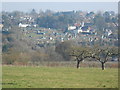
View Across the Valley to Loose
Showing the allotments and Loose Hill.
Image: © Danny P Robinson
Taken: 4 Mar 2013
0.06 miles
7
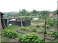
Allotments at Loose Kent
Valuable open space and amenity for local use
Image: © Robert Taylor
Taken: 6 May 2007
0.06 miles
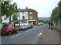
10
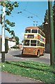
British Trolleybuses - Maidstone
Maidstone was the smallest British trolleybus system to survive into the 60s. It was basically a single route from Barming in the west to Sutton Road in the south with a branch off the latter to Loose. This resulted in the splendid destination display to be seen in this picture.
This trolleybus is arriving at the Loose terminus which was a few hundred yards short of the old village itself, at the top of Old Loose Hill. The surroundings appear to be little changed, although the pub sign pole (at the left) no longer appears to be there.
For a slide show of British Trolleybuses in the late 60s http://www.geograph.org.uk/search.php?i=1773236&displayclass=slide
Image: © Alan Murray-Rust
Taken: 10 Sep 1966
0.08 miles