IMAGES TAKEN NEAR TO
McAlpine Crescent, MAIDSTONE, ME15 0AU
Introduction
This page details the photographs taken nearby to McAlpine Crescent, ME15 0AU by members of the Geograph project.
The Geograph project started in 2005 with the aim of publishing, organising and preserving representative images for every square kilometre of Great Britain, Ireland and the Isle of Man.

There are currently over 7.5m images from over14,400 individuals and you can help contribute to the project by visiting https://www.geograph.org.uk
Image Map
Images are licensed for reuse under creativecommons.org/licenses/by-sa/2.0
Notes
- Clicking on the map will re-center to the selected point.
- The higher the marker number, the further away the image location is from the centre of the postcode.
Image Listing (59 Images Found)
Images are licensed for reuse under creativecommons.org/licenses/by-sa/2.0
Image
Details
Distance


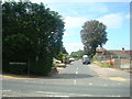
4

Footpath junction near MacAlpine Crescent
Footpath under green tunnel leads past Gordon Court to Forstal Lane. Crossing this path is a path from B2163 Heath Road to High Banks, Loose.
Image: © David Anstiss
Taken: 21 Jan 2009
0.03 miles

6
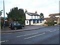
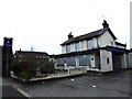
The Star Pub, Loose
On 74 Linton Road, A229. Close to MacAlpine Crescent.
Image: © David Anstiss
Taken: 21 Jan 2009
0.03 miles