IMAGES TAKEN NEAR TO
Haywain Close, MAIDSTONE, ME14 5UX
Introduction
This page details the photographs taken nearby to Haywain Close, ME14 5UX by members of the Geograph project.
The Geograph project started in 2005 with the aim of publishing, organising and preserving representative images for every square kilometre of Great Britain, Ireland and the Isle of Man.

There are currently over 7.5m images from over14,400 individuals and you can help contribute to the project by visiting https://www.geograph.org.uk
Image Map
Images are licensed for reuse under creativecommons.org/licenses/by-sa/2.0
Notes
- Clicking on the map will re-center to the selected point.
- The higher the marker number, the further away the image location is from the centre of the postcode.
Image Listing (38 Images Found)
Images are licensed for reuse under creativecommons.org/licenses/by-sa/2.0
Image
Details
Distance
1
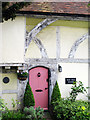
Yew Tree House
Entrance door and timber bracing of Image
Image: © Oast House Archive
Taken: 2 May 2009
0.04 miles
2
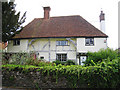
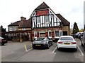
Yew Tree House, Weavering Street, Boxley, Kent
Grade II listed Wealden hall house.
Image: © Oast House Archive
Taken: 2 May 2009
0.04 miles

6
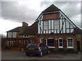
The Fox & Goose, Weavering Street, Maidstone
Image: © Chris Whippet
Taken: 1 Apr 2010
0.06 miles
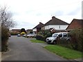
7
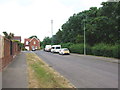
Grovewood Drive South, Grove Green
Grovewood Drive North and South were separated for some years by a small patch of ground. Maidstone council reserved the land in case they ever decided to connect the two but recently allowed planning permission for houses to be built there.
Image: © Chris Whippet
Taken: 20 Jul 2013
0.07 miles
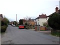
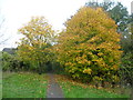
9
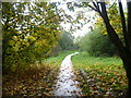
Path leading to Grovewood Drive South
The railway line between Maidstone East and Bearsted is just to the left here. A footpath from Roseacre drops down into a valley, then uphill to cross the railway line. Turning left this is then the view on the way to Grovewood Drive South.
Image: © Marathon
Taken: 12 Nov 2013
0.09 miles
10
Path to Roseacre
The railway line between Maidstone East and Bearsted is just to the right here. Just ahead a footpath another footpath from Weavering Street is joined. Turning right this crosses the railway line, then drops down into a valley, and uphill on the other side to Roseacre.
Image: © Marathon
Taken: 12 Nov 2013
0.09 miles