IMAGES TAKEN NEAR TO
Franklin Drive, MAIDSTONE, ME14 5SY
Introduction
This page details the photographs taken nearby to Franklin Drive, ME14 5SY by members of the Geograph project.
The Geograph project started in 2005 with the aim of publishing, organising and preserving representative images for every square kilometre of Great Britain, Ireland and the Isle of Man.

There are currently over 7.5m images from over14,400 individuals and you can help contribute to the project by visiting https://www.geograph.org.uk
Image Map
Images are licensed for reuse under creativecommons.org/licenses/by-sa/2.0
Notes
- Clicking on the map will re-center to the selected point.
- The higher the marker number, the further away the image location is from the centre of the postcode.
Image Listing (49 Images Found)
Images are licensed for reuse under creativecommons.org/licenses/by-sa/2.0
Image
Details
Distance
1
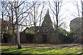
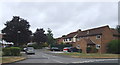
Cherry Oast, Franklin Drive, Weavering, Kent
Single round kiln oast house, like many in the area, now amongst a large housing estate.
Image: © Oast House Archive
Taken: 8 Feb 2008
0.04 miles
2
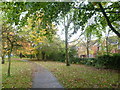
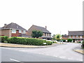
Grovewood Drive South
This path runs alongside Grovewood Drive South. This is not far from Vinters Park.
Image: © Marathon
Taken: 12 Nov 2013
0.05 miles
3
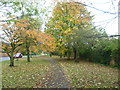
Path alongside Grovewood Drive South
This is not far from Vinters Park.
Image: © Marathon
Taken: 12 Nov 2013
0.05 miles
6
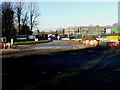
Entrance to building site, New Cut Road
Planning permission has been granted by Maidstone Borough Council under application number 17/501471/FULL for the “erection of a three storey secondary school with associated access, car parking and landscaping”. It is being built on land at Valley Park School, New Cut Road.
This was the Image in February 2019.
Image: © John Baker
Taken: 21 Jan 2020
0.09 miles
7
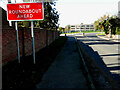
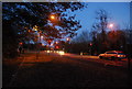
Grovewood Drive
The road sign has been erected recently, beside this road, to warn motorists of the roundabout that has been installed on New Cut Road. The roundabout was presumably installed, due to the erection of a three storey secondary school at Valley Park School, in order to provide a safer exit/access from/to the school.
Image: © John Baker
Taken: 4 Nov 2020
0.09 miles
9

Entrance to building site, New Cut Road
Planning permission has been granted by Maidstone Borough Council under application number 17/501471/FULL for the “erection of a three storey secondary school with associated access, car parking and landscaping”. It will be built on land at Valley Park School, New Cut Road.
This was the Image in January 2020.
Image: © John Baker
Taken: 7 Feb 2019
0.10 miles