IMAGES TAKEN NEAR TO
Speedwell Close, MAIDSTONE, ME14 5SX
Introduction
This page details the photographs taken nearby to Speedwell Close, ME14 5SX by members of the Geograph project.
The Geograph project started in 2005 with the aim of publishing, organising and preserving representative images for every square kilometre of Great Britain, Ireland and the Isle of Man.

There are currently over 7.5m images from over14,400 individuals and you can help contribute to the project by visiting https://www.geograph.org.uk
Image Map
Images are licensed for reuse under creativecommons.org/licenses/by-sa/2.0
Notes
- Clicking on the map will re-center to the selected point.
- The higher the marker number, the further away the image location is from the centre of the postcode.
Image Listing (35 Images Found)
Images are licensed for reuse under creativecommons.org/licenses/by-sa/2.0
Image
Details
Distance
1
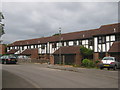
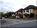
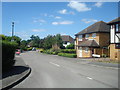
Mock Tudor houses on Harvesters Way
Part of the Grove Green Housing estate.
Image: © David Anstiss
Taken: 13 Jul 2011
0.09 miles


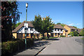
6
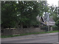
East Lodge, Vinters Park Maidstone
Beside New Cut Road.
Part of the former estate of Vinters Park.
Image: © David Anstiss
Taken: 13 Jul 2011
0.18 miles