IMAGES TAKEN NEAR TO
Bargrove Road, MAIDSTONE, ME14 5SB
Introduction
This page details the photographs taken nearby to Bargrove Road, ME14 5SB by members of the Geograph project.
The Geograph project started in 2005 with the aim of publishing, organising and preserving representative images for every square kilometre of Great Britain, Ireland and the Isle of Man.

There are currently over 7.5m images from over14,400 individuals and you can help contribute to the project by visiting https://www.geograph.org.uk
Image Map
Images are licensed for reuse under creativecommons.org/licenses/by-sa/2.0
Notes
- Clicking on the map will re-center to the selected point.
- The higher the marker number, the further away the image location is from the centre of the postcode.
Image Listing (35 Images Found)
Images are licensed for reuse under creativecommons.org/licenses/by-sa/2.0
Image
Details
Distance
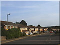
4
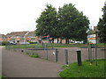
Bedgebury Close Play Area
Within the Vinters Park housing estate.
Image: © David Anstiss
Taken: 13 Jul 2011
0.10 miles
5
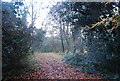
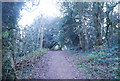
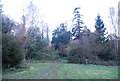
Track through Vinters Valley Nature Reserve
Image: © N Chadwick
Taken: 28 Nov 2010
0.10 miles
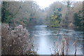
10
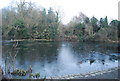
Vinters Valley Nature Reserve - frozen lake
Image: © N Chadwick
Taken: 28 Nov 2010
0.13 miles