IMAGES TAKEN NEAR TO
Vinters Business Park, New Cut Road, MAIDSTONE, ME14 5NZ
Introduction
This page details the photographs taken nearby to Vinters Business Park, New Cut Road, ME14 5NZ by members of the Geograph project.
The Geograph project started in 2005 with the aim of publishing, organising and preserving representative images for every square kilometre of Great Britain, Ireland and the Isle of Man.

There are currently over 7.5m images from over14,400 individuals and you can help contribute to the project by visiting https://www.geograph.org.uk
Image Map
Images are licensed for reuse under creativecommons.org/licenses/by-sa/2.0
Notes
- Clicking on the map will re-center to the selected point.
- The higher the marker number, the further away the image location is from the centre of the postcode.
Image Listing (40 Images Found)
Images are licensed for reuse under creativecommons.org/licenses/by-sa/2.0
Image
Details
Distance
1
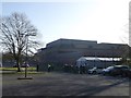
The Maidstone Studios
It was formerly called TVS Television Centre. It is a television studio complex with radio studio facilities based at Vinters Park. It has been home to a varied selection of independent British television programming including quiz shows, such as the original run of Catchphrase and popular children's shows such as CITV's Art Attack.
In April 2013, Jools Holland (a local Kent resident) started recording the BBC show - 'Later...with Jools Holland' at the studios.
Image: © David Anstiss
Taken: 16 Apr 2013
0.03 miles
3
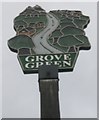
Close-up of Grove Green Village Sign
As seen in Image
Has a small metal plaque on the post which reads "Boxley Parish Council 2000. Artwork by Graham Webb".
Image: © David Anstiss
Taken: 13 Jul 2011
0.12 miles
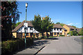
4
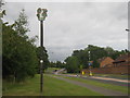
Grove Green Village Sign
On Grovewood Drive.
Image: © David Anstiss
Taken: 13 Jul 2011
0.13 miles
5
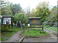
Entrance to Vinters Valley Nature Reserve
Vinters Valley Nature Reserve is the remaining part of a large country estate with a long and eventful history. During the war the house was taken over by the Army. Having been empty for a few years the entire estate comprising of 660 acres was sold to a property developer in 1956. Shortly after this the house burnt down, and was demolished.
Vinters housing estate was built on the hop gardens and wheat fields to the west, and later Grove Green covered the former market garden on the east - see http://www.geograph.org.uk/photo/3746879 Parkland became school playing fields, and the rest of the land became overgrown. A local couple Donal and Lida MacGrory found the site one day and set about saving the land from further development. With the support of other local residents further planning permission was reduced and eventually Kent County Council bought the remaining land. The County Council opened the land up as a park in 1987 and began to employ Lida. It was transferred to a Trust in 1987 with a 99 year lease. The site was awarded Local Nature Reserve status in 1992.
For a complete history of the park see http://vintersvalley.co.uk/aboutthereserve.php
Image: © Marathon
Taken: 12 Nov 2013
0.14 miles
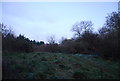
9
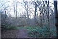
Vinters Valley Nature Reserve - woodland
Image: © N Chadwick
Taken: 28 Nov 2010
0.15 miles
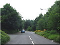
10
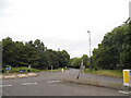
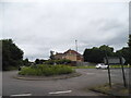
Roundabout on New Cut Road, Weavering
Image: © David Howard
Taken: 19 Jun 2016
0.16 miles