IMAGES TAKEN NEAR TO
Hockers Lane, MAIDSTONE, ME14 5JY
Introduction
This page details the photographs taken nearby to Hockers Lane, ME14 5JY by members of the Geograph project.
The Geograph project started in 2005 with the aim of publishing, organising and preserving representative images for every square kilometre of Great Britain, Ireland and the Isle of Man.

There are currently over 7.5m images from over14,400 individuals and you can help contribute to the project by visiting https://www.geograph.org.uk
Image Map
Images are licensed for reuse under creativecommons.org/licenses/by-sa/2.0
Notes
- Clicking on the map will re-center to the selected point.
- The higher the marker number, the further away the image location is from the centre of the postcode.
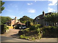
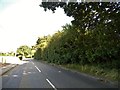
Image Listing (13 Images Found)
Images are licensed for reuse under creativecommons.org/licenses/by-sa/2.0
Image
Details
Distance
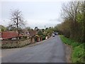
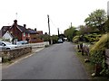
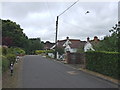
3
Weavering Street
The Give Way sign on the left still remains despite the Weavering Street junction with Ware Street and Bearsted Road being stopped up in the 1980s.
Image: © Chris Whippet
Taken: 22 Apr 2016
0.14 miles
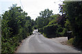
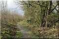
10
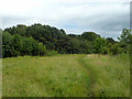
Path towards Honeyhills Wood
A sign at the start of the path gives a 'Woodland Welcome', and states that by agreement with the owner you are welcome to walk in these woods.
Image: © Robin Webster
Taken: 17 Jul 2012
0.25 miles