IMAGES TAKEN NEAR TO
Norman Close, MAIDSTONE, ME14 5HT
Introduction
This page details the photographs taken nearby to Norman Close, ME14 5HT by members of the Geograph project.
The Geograph project started in 2005 with the aim of publishing, organising and preserving representative images for every square kilometre of Great Britain, Ireland and the Isle of Man.

There are currently over 7.5m images from over14,400 individuals and you can help contribute to the project by visiting https://www.geograph.org.uk
Image Map (Loading...)


Getting Data...Please wait
Leaflet Map data © OpenStreetMap
Images are licensed for reuse under creativecommons.org/licenses/by-sa/2.0
Notes
- Clicking on the map will re-center to the selected point.
- The higher the marker number, the further away the image location is from the centre of the postcode.
Image Listing (40 Images Found)
Images are licensed for reuse under creativecommons.org/licenses/by-sa/2.0
Image
Details
Distance
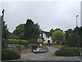
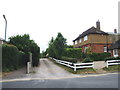
3
Tudor Avenue, Maidstone
Tudor Avenue is a residential road in Maidstone, Kent.
Image: © Malc McDonald
Taken: 2 Nov 2013
0.10 miles
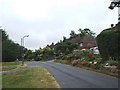
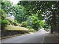
5
Junction of Wheeler Street Hedges and Heathfield Road, Penenden Heath
Image: © Chris Whippet
Taken: 20 Jul 2013
0.10 miles
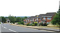
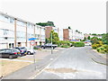
7
Hampton Road
One of the main ways in to an extensive housing development.
Image: © Robin Webster
Taken: 17 Jul 2012
0.11 miles
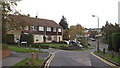
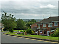
10
Tudor Avenue, Maidstone
Tudor Avenue is a residential road in Maidstone, Kent.
Image: © Malc McDonald
Taken: 2 Nov 2013
0.13 miles