IMAGES TAKEN NEAR TO
Hatherall Road, MAIDSTONE, ME14 5HE
Introduction
This page details the photographs taken nearby to Hatherall Road, ME14 5HE by members of the Geograph project.
The Geograph project started in 2005 with the aim of publishing, organising and preserving representative images for every square kilometre of Great Britain, Ireland and the Isle of Man.

There are currently over 7.5m images from over14,400 individuals and you can help contribute to the project by visiting https://www.geograph.org.uk
Image Map
Images are licensed for reuse under creativecommons.org/licenses/by-sa/2.0
Notes
- Clicking on the map will re-center to the selected point.
- The higher the marker number, the further away the image location is from the centre of the postcode.
Image Listing (38 Images Found)
Images are licensed for reuse under creativecommons.org/licenses/by-sa/2.0
Image
Details
Distance
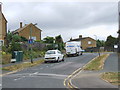
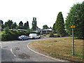
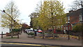
2
Curzon Road, Maidstone
Curzon Road is a residential road in Maidstone, Kent.
Image: © Malc McDonald
Taken: 2 Nov 2013
0.09 miles
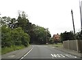
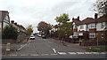
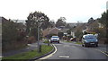
9
St. Luke's Road, Maidstone
The road has been blocked off at this junction to prevent drivers from using it as a short-cut.
Image: © Malc McDonald
Taken: 2 Nov 2013
0.16 miles
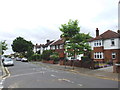
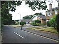
10
Tudor Avenue, Maidstone
Tudor Avenue is a residential road in Maidstone, Kent.
Image: © Malc McDonald
Taken: 2 Nov 2013
0.16 miles