IMAGES TAKEN NEAR TO
Ashford Road, MAIDSTONE, ME14 5DL
Introduction
This page details the photographs taken nearby to Ashford Road, ME14 5DL by members of the Geograph project.
The Geograph project started in 2005 with the aim of publishing, organising and preserving representative images for every square kilometre of Great Britain, Ireland and the Isle of Man.

There are currently over 7.5m images from over14,400 individuals and you can help contribute to the project by visiting https://www.geograph.org.uk
Image Map
Images are licensed for reuse under creativecommons.org/licenses/by-sa/2.0
Notes
- Clicking on the map will re-center to the selected point.
- The higher the marker number, the further away the image location is from the centre of the postcode.
Image Listing (82 Images Found)
Images are licensed for reuse under creativecommons.org/licenses/by-sa/2.0
Image
Details
Distance
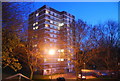
4
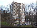
Sunningdale Court, Square Hill Rd, Maidstone, Kent ME15 7TU
Formerly managed by Maidstone Borough Council, now managed by Golding Homes.
Image: © Danny P Robinson
Taken: 2 Feb 2015
0.06 miles


10

Invicta Grammar School
One of two Girl's Grammar Schools in Maidstone.
Image: © N Chadwick
Taken: 28 Nov 2010
0.07 miles