IMAGES TAKEN NEAR TO
Maxton Close, MAIDSTONE, ME14 4QD
Introduction
This page details the photographs taken nearby to Maxton Close, ME14 4QD by members of the Geograph project.
The Geograph project started in 2005 with the aim of publishing, organising and preserving representative images for every square kilometre of Great Britain, Ireland and the Isle of Man.

There are currently over 7.5m images from over14,400 individuals and you can help contribute to the project by visiting https://www.geograph.org.uk
Image Map
Images are licensed for reuse under creativecommons.org/licenses/by-sa/2.0
Notes
- Clicking on the map will re-center to the selected point.
- The higher the marker number, the further away the image location is from the centre of the postcode.
Image Listing (40 Images Found)
Images are licensed for reuse under creativecommons.org/licenses/by-sa/2.0
Image
Details
Distance
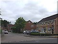
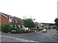
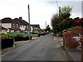
2
Averenches Road, Bearsted
This road is stopped up from Averenches Road South to prevent it being used as a rat run to the Grove Green estate.
Image: © Chris Whippet
Taken: 20 Jul 2013
0.08 miles
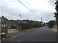
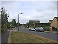
4
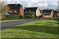
Grovewood Drive
Seen from the junction with Weavering Street
Image: © David Martin
Taken: 17 Mar 2023
0.10 miles