IMAGES TAKEN NEAR TO
Ware Street, MAIDSTONE, ME14 4PQ
Introduction
This page details the photographs taken nearby to Ware Street, ME14 4PQ by members of the Geograph project.
The Geograph project started in 2005 with the aim of publishing, organising and preserving representative images for every square kilometre of Great Britain, Ireland and the Isle of Man.

There are currently over 7.5m images from over14,400 individuals and you can help contribute to the project by visiting https://www.geograph.org.uk
Image Map (Loading...)


Getting Data...Please wait
Leaflet Map data © OpenStreetMap
Images are licensed for reuse under creativecommons.org/licenses/by-sa/2.0
Notes
- Clicking on the map will re-center to the selected point.
- The higher the marker number, the further away the image location is from the centre of the postcode.
Image Listing (62 Images Found)
Images are licensed for reuse under creativecommons.org/licenses/by-sa/2.0
Image
Details
Distance
2
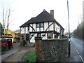
Wealden Hall House, Ware Street, Thurnham, Kent
Grade II listed.
Image: © Oast House Archive
Taken: 8 Feb 2008
0.03 miles
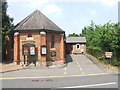
3
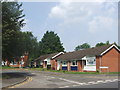
Bearsted Methodist Church
On Ware Street, opposite Hog Hill Lane.
Image: © David Anstiss
Taken: 26 Dec 2008
0.04 miles
4
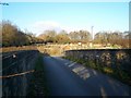
Bridge over Railway
Leads to Bearsted Golf Course from Ware Street. Also used by footpath to Detling or Thurnham Villages. Allotment seen on other side of railway cutting.
Image: © David Anstiss
Taken: 26 Dec 2008
0.04 miles
5
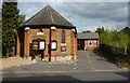
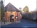
Bearsted Methodist Church on the north side of Ware Street
Situated opposite Hog Hill.
Image: © pam fray
Taken: 1 Oct 2009
0.05 miles
8
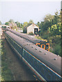
A view of Bearsted Station from the railway bridge
Bearsted Station is between Maidstone East and Ashford.
Image: © pam fray
Taken: 1 Oct 2009
0.06 miles
9
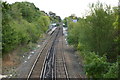
Trains passing at Bearsted
Two class 423 units pass at Bearsted: at left, 3471 on the 15.18 Victoria to Ashford, and at right 3583 on the 15.36 Canterbury West to Victoria.
For a view of the station itself see Image I am intrigued by the building to the side of the railway line - probably a railway property, maybe an old goods shed?
Image: © Stephen Craven
Taken: 8 Sep 1998
0.09 miles