IMAGES TAKEN NEAR TO
Ashford Road, MAIDSTONE, ME14 4NQ
Introduction
This page details the photographs taken nearby to Ashford Road, ME14 4NQ by members of the Geograph project.
The Geograph project started in 2005 with the aim of publishing, organising and preserving representative images for every square kilometre of Great Britain, Ireland and the Isle of Man.

There are currently over 7.5m images from over14,400 individuals and you can help contribute to the project by visiting https://www.geograph.org.uk
Image Map
Images are licensed for reuse under creativecommons.org/licenses/by-sa/2.0
Notes
- Clicking on the map will re-center to the selected point.
- The higher the marker number, the further away the image location is from the centre of the postcode.
Image Listing (14 Images Found)
Images are licensed for reuse under creativecommons.org/licenses/by-sa/2.0
Image
Details
Distance
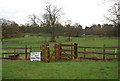
1

Grassy knoll by Ashford Road
It's become a cliche so I had to use it when appropriate. Outside the Tudor Park Marriott Hotel.
Image: © David Howard
Taken: 12 Jun 2016
0.05 miles
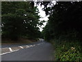
4

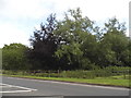
A20 east of Bearsted
A quiet moment on Christmas Eve. The road is much quieter than it was before the M20 motorway was extended from Hollingbourne to Folkestone but still has its busy moments.
Image: © Penny Mayes
Taken: 24 Dec 2005
0.17 miles
6
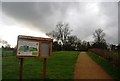
Bearsted Woodland Trust Sign by the path to Sutton Street
Image: © N Chadwick
Taken: 29 Nov 2009
0.19 miles
7
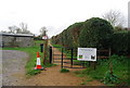
Kissing gate at the entrance to Bearsted Woodland Trust
Image: © N Chadwick
Taken: 29 Nov 2009
0.20 miles